
This post was written by Heather Chiles, an Engagement and Marketing Strategy staff member at the National Geographic Society.
As an educator, you have worked hard to develop engaging lesson plans that will resonate with your students. We’ve spent the last ten years crafting the ultimate learning resource to bring your classroom the latest in GIS software.

Geography and mapping have always been a way of pulling information together. By learning about mapping skills and geography, students can understand how the world’s most crucial issues, challenges, and opportunities fit into the context of place. Now, we’ve teamed up with Esri, the global leader in geographic information systems to launch a reimagined version of National Geographic MapMaker.
Below, check out some of the new and exciting features on MapMaker to learn how you and your students can build and explore maps that help illustrate connections between people, places, and phenomena.
MapMaker is designed specifically for teachers and students.
This free tool runs on lightweight devices, making learning in the classroom, at home, or an outdoor lesson day effortless.
Check out these students from Foulks Ranch Elementary interacting with the engaging features of MapMaker, and inspire your students to leverage technology to advance their learning specific to their unique interests and dynamic lesson plans.
MapMaker doesn’t require a log-in and is free, intuitive, and straight-forward to avoid disruptive technical difficulties in the classroom.
Whether teaching your students about biomes, climate change, population, or the environment, MapMaker adds innovative learning to your classroom.
Layers have informative descriptions based on accurate data-backed sources to take your students on a mapmaking journey.
Explore New Features with the reimagined MapMaker
Explore the world with the New 3D and Globe Map View! Engage your students with 3D dynamic landscapes and effortlessly switch between stunning Basemaps such as the Topographic or Imagery Hybrid view.
The Globe view allows your students to pinpoint data to a precise location or zoom out to an interactive global worldview! It is convenient and full of powerful features for exploring the world through data-driven maps in 2D and 3D views.

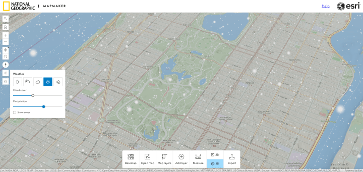
The Weather and Daylight Simulation Tools help your students bring their unique world to life whether their individualized map is snowing in the morning…
or cloudy at sunset…

The Measurement Tool allows your students to precisely calculate coordinates and measure varied distances with over ten units of measurement.
MapMaker is localized for different languages for accessibility wherever your classroom is around the globe.
The Layer Swipe tool gives your students valuable insight into what the world looks like with and without the data. The transparency of the layer can also be adjusted when displaying multiple layers at once.
The Mangrove Watch Layer is one of many layers supported by Explorer research with straight-forward descriptions.

Students can bookmark their map directly on MapMaker for a fun presentation at the end of your lesson plan to spark a lively discussion!
More from Nat Geo Leadership: Dr. Deborah Greyson, Chief Education Officer.
Take your classroom across the world and dive into Explorer research! Teaching about real-world Explorers inspires learners to think like an Explorer, expanding curiosity, knowledge, and critical thinking. By leveraging and promoting National Geographic Society education in classrooms, GIS professionals can help to inspire the next generation of Explorers.
Dr. Deborah R. Grayson, NGS Chief Education Officer, believes there is a direct correlation between using the Geographic Approach and driving real change in the world.
“Over the last year, the National Geographic Society has worked closely with Esri to create a new version of the National Geographic MapMaker. Built on the ArcGIS platform, students will be able to use maps and data in new and exciting ways, equipping them with the tools for better geographic inquiry and problem-solving,” Dr. Grayson says. “This innovative tool is a game changer for teachers and students enabling them to explore the Earth’s interconnected systems through a collection of curated base maps, data layers, and tutorials. They will access real-world examples and data from Explorers to see how GIS and the geographic approach addresses challenges around the world.”
-Dr. Deborah R. Grayson, NGS Chief Education Officer
View Dr. Grayson’s full presentation from the 2023 ESRI Education Summit online.
MapMaker is Perfect for Any Classroom!
This GIS tool reaches beyond the scope of a traditional map and provides your students with interactive data on a variety of important topics. Students can see patterns and relationships by layering maps, adding notes and sketches to maps, and saving images for use in papers, presentations, or other apps.
Empower Your Students to Create Their Own World Through MapMaker

Looking for new ways to engage and motivate your students in the upcoming school year?
It’s no secret that new technology has become even more prevalent throughout society, mainstream media, and even the classroom environment. Research shows active learning approaches lead to increased student engagement, critical thinking, and motivation.

MapMaker is versatile and engages students whether they are in Kindergarten or 12th grade.
MapMaker’s content resonates throughout K-12 learning. Spend a lesson on naming the continents or following the intricacies of biodiversity in relation to climate change. The Layer descriptions conveniently link to valuable resources, such as vocabulary and infographics – perfect to encourage even the youngest of emerging geographers and cartographers!
Educators! Share your voice! Share a photo using the MapMaker with the hashtags #MapMaker #GeographyTeacher #EarthScience
Note: For those of you using MapMaker 2.0, it will still be available through the 2023-2024 school year before we migrate to the new platform.